Two approaching storms are expected to bring heavy rain and strong wind gusts to Northern California starting Jan. 19.
The wet weather could last until Wednesday in some regions of the state as atmospheric river systems deliver warm air and moisture from the tropics to the Golden State, according to the National Weather Service.
Some mountain areas could also drop “Sierra cement”—or heavy wet snow—to higher elevations above 6,000 feet, according to Meteorologist Kate Forrest, with the weather service’s Sacramento office.

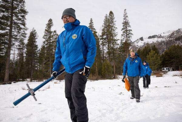
Engineers from the California Department of Water Resources Snow Surveys and Water Supply Forecasting Unit prepare to conduct a snow survey in the Sierra Nevada in El Dorado County. Calif., on Jan. 2, 2024. (Xavier Mascareñas/California Department of Water Resources)
“We’re definitely going to be expecting a couple of inches up to one foot [of snow] at the higher peaks with these storms,” Ms. Forrest told The Epoch Times.
The first storm was expected to enter the Sacramento Valley after about 4 p.m. Friday and wrap up early Sunday. Then, after a brief break, the second storm could arrive later Sunday afternoon and remain in the region until Tuesday.
Lingering showers could continue to fall in the Sacramento Valley foothills and mountain areas through Tuesday, according to the weather service.
“There may even be some brief, lingering light showers on Wednesday, as well, as part of a different activity, but that will mostly be just moisture exiting the area,” Ms. Forrest said.
During the first storm, most of the rain is slated to fall around the northern Sacramento Valley and surrounding mountains and foothills, where residents could see anywhere between 1 to 4 inches of precipitation.
The storm systems are typical for this time of year, Ms. Forrest added.
“This isn’t anything terribly out of the ordinary for the area,” she said. “We would consider this to be a storm that drops some healthy precipitation, drop some snow in the snowpack, and saturate the ground.”
The second storm should drop more rain in the valley, where residents could get up to 1.5 inches of rain.
The weather service has issued a flood watch in the Sacramento Valley for Sunday afternoon through Monday night, anticipating some minor flooding in cities.
The region could also see wind gusts up to 45 miles per hour through Saturday evening, according to the weather service.
The incoming storms are expected to bring moderate to heavy rainfall to the San Francisco Bay Area starting Friday and lasting through Monday. This could cause fast-rising water levels along streams and creeks in the region, according to the weather service’s office in Monterey, California.
Most waterways are expected to stay below flood levels, but some locations could rise requiring monitoring, especially in Sonoma County, the weather service said.

Water flows down the spillway at Nicasio Reservoir after days of rain have brought the reservoir to near capacity in Nicasio, Calif., on Jan. 9, 2023. (Justin Sullivan/Getty Images)
The forecast shows a greater-than 20-percent chance of the Russian River at Guerneville—a small city located about 75 miles north of San Francisco—reaching flood stage by late Monday night, according to a Jan. 18 outlook report by the weather service.
The Bay Area could see up to 3 inches of rain across most areas with 3 to 5 inches expected over the North Bay, which includes the state’s wine regions in Marin, Napa, Sonoma, and Solano counties.
The Santa Cruz and Santa Lucia Mountains could see as much as 4 to 6 inches of rain, the weather service reported.
With this weekend’s additional rain falling in the San Francisco Bay Area, shallow soils on steep hills are expected to become saturated, which means widespread shallow landslides are likely, according to the United States Geographical Survey.
Further south in San Luis Obispo and Santa Barbara, along the central coast, the weather service forecasted possible thunderstorms beginning Sunday night and lasting through Monday. Rain was anticipated in those counties from Friday through Wednesday.
In Ventura and Los Angeles counties, rain could arrive Friday night and last until late Monday, according to the weather service. The heaviest downpours were forecast for Saturday. Thunderstorms could also reach Los Angeles and Ventura counties Monday.
In Orange and San Diego counties, residents should expect light showers to begin Saturday in the region, with Monday bringing the greatest threat of rain, according to an update provided by Alex Tardy, a senior meteorologist with the weather service in the San Diego office.

A view of snow-covered mountains from Orange County, Calif., on Dec. 29, 2021. (John Fredricks/The Epoch Times)
Mountain areas in Southern California could receive some wet snow as the two storms pass through, he said.
The snow level will be at its lowest point in the southern region of the state Saturday night, dipping as low as 5,500 feet, he reported.
“We could see some heavy rain and isolated thunderstorms Saturday night,” Mr. Tardy added.
The second storm will also bring a threat of thunderstorms to the San Diego region, but then the southern region of the state will get a chance to dry out after these systems, he said.
“For the rest of the month it looks like we don’t get any more rain, so things really dry out after Monday,” he added. “This is kind of a one-two punch.”


