
The catastrophic flooding in central Texas was described by National Oceanic and Atmospheric Administration hydrologist Greg Waller of the West Gulf River Forecast Center in Fort Worth, Texas, as the perfect storm when it comes to forecasting rivers.
“In the river forecasting world, this was one of those that we will be training our forecasters on, because we know it will happen again,” Waller told The Epoch Times. “[Maybe in] 10 years? Twenty years? Thirty years? But we do know it will happen again, and we have to have this dataset available for experience.”
That perfect combination of circumstances brought together the moisture remnants of Tropical Storm Barry up from Mexico with a low-pressure system known as a trough over a geologic formation Waller called the Balcones Escarpment, which causes air masses to rapidly rise hundreds of feet and trigger intense storms. Central Texas features areas of shallow soil on rocky terrain susceptible to becoming large and fast-moving masses of runoff.
“The terrain up there, there is not a lot of soil,” Bob Fogarty, National Weather Service meteorologist at the Austin/San Antonio office, told The Epoch Times. “Soil saturates, and it’s all rock underneath, and it’s all runoff.”
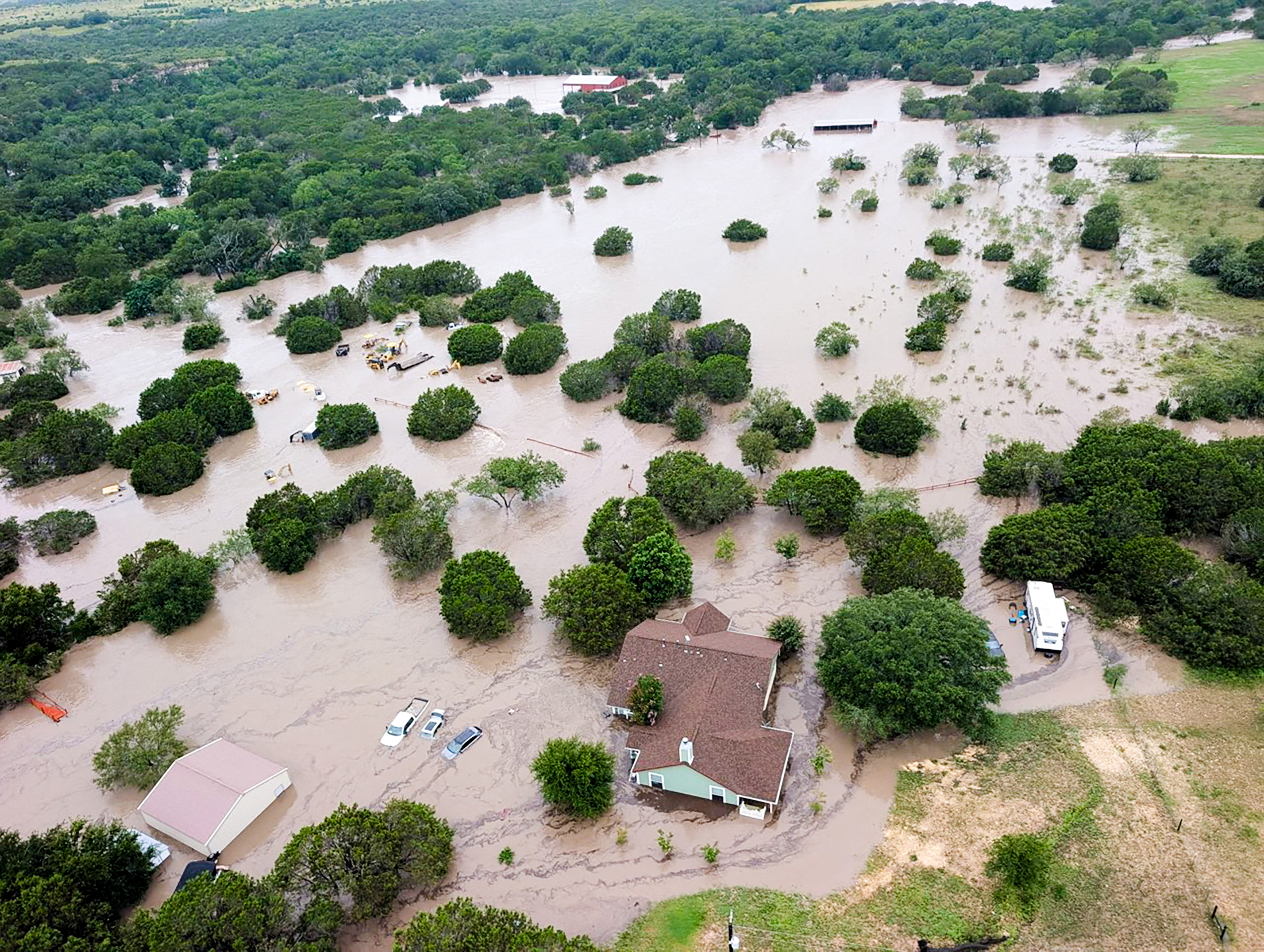
That developing storm also hovered over those areas of rocky soil, dropping 10 inches of rain on the basin in three to four hours. Some areas even received up to 15 to 16 inches of rain.
Waller emphasized that it was the rainfall rate that determined how the river would flood.
“Two inches over 24 hours produces a different runoff pattern than two inches in half an hour,” he said.
Two days after the fact, water levels along the Guadalupe River appeared to return to normal levels, but Waller confirmed that a rainfall rate of 1 1/2 to two inches per hour would trigger flood warnings once again.
Slow-Moving Storm
According to Fogarty, who also agreed that the term “perfect storm” was an appropriate description for the event, the rain began to fall at about midnight on July 4 from the unexpectedly slow-moving storm.
“It was a bit more than we thought,” Fogarty said, regarding the amount of rainfall. “The forecast models didn’t account for the slower movement of the storm.”
Waller emphasized that both offices stood by, having arranged sufficient staffing so they were ready to monitor and report on the storm as it developed through the night.
“Normally, the river forecast center shuts down at 10 o'clock at night and reopens at six,” Waller said. “We identified the heavy rainfall threat Thursday afternoon and augmented our staffing to ensure that we had appropriate coverage. ... We had staff in reserve ready to go if we needed them.”
The first flash flood warning was issued to Bandera County at 11:40 p.m. CDT on July 3. But the first warning to Kerr County to trigger cellphones went out at 1:14 a.m. on July 4.
Fogarty said the storm was dumping rain into both the north and south forks of the eastward-flowing Guadalupe River, which converge around the town of Hunt, Texas. The area, part of Texas Hill Country, attracts a large vacationing population, including for the July 4 holiday.
At 3:19 a.m., the National Weather Service issued its first river flood warning, stating that water levels near Hunt had reached 11 feet, and that “the Highway 39 bridge floor near Hunt” was under six feet of water.
“Some residents are cut off and should stay put,” it stated.
Flood Height
The flood stage—the height the river must reach for the water to start becoming hazardous to life and property—for Hunt is 10 feet.
Waller explained that, unlike a flash flood warning, which could be issued anywhere in the country, a river flood warning is one specifically tied to the immediate area around a river.
At 3:50 a.m., the service updated its warning, announcing that the river height near Hunt had reached 19.4 feet and was expected to reach beyond 23 feet.
“At 25 feet, major flooding severely floods resort camps along the South Fork below the River Inn Resort to Hunt,” it warned.
At 4:46 a.m., a warning was issued for Kerrville, stating that waters there had reached seven feet and were forecast to reach 25 feet that morning. The flood stage for Kerrville is nine feet.
At 6:05 a.m., the town of Comfort, Texas, was warned that the river was forecast to rise to 30.6 feet. Its flood stage is 21 feet.
The West Gulf River Forecast Center uses the flood gauge of the U.S. Geological Survey (USGS) along the Guadalupe River.
The gauge around Kerrville recorded a rise of 22 feet in less than two hours.
The gauge near Hunt recorded a floodwater height of 29.45 feet at 4:45 a.m. on July 4 before it went offline. The USGS conducted a survey on the gauge, and an official maximum height of the water in that area is expected to be determined.
“We do anticipate that that number will probably go up at that point,” Waller said of the maximum water levels. “There’s probably either water in the gauge house or something happened to the gauge structure itself to take it offline. So we’re waiting on the USGS high watermark when they get their survey completed.”
Waller compared this flood to the 2015 floods of the Blanco River near Wimberley, Texas, and the Guadalupe River flood of 1987, which saw the river at Kerrville rise to 37.7 feet.
Deadly Tragedy
But to Waller, the real tragedy this time came from the loss of human life in what he called the combination of Mother Nature and “a socially vulnerable population.”
“A lot of the tragedy is also the timing of an overnight event right on a holiday weekend with a population that wasn’t familiar,” he said. “They were visiting, which is, again, similar to the Wimberley floods, overnight visiting population in a very sensitive area.”
He also said the storm extended out more than 100 miles, causing flooding events not just on the Guadalupe River, but also on the Medina River, the Llano River, the San Saba River, and even the Colorado River. Minor and moderate flood warnings were also issued for several of those rivers.
“That’s also the difficulty of Texas hydrology,” he said. “In that area, the river basins are kind of narrow. You could be off 20 miles on a rainfall forecast. And that’s two different river systems.”
Not Out of the Woods Yet
The Lone Star State does not appear to be out of the woods just yet. Flood watches and warnings were in effect across central Texas throughout July 6 as yet another wave of heavy rain was expected.
“If that heavy rain signature comes down, we will issue our river forecast, and they will issue warnings as needed, but we will ... because we’re not out of the woods,” Waller said. “They’re still in the flood watch, and we need to be diligent because now it’s also [about] the lives of the first responders along with recovery.”
Fogarty agreed. Having worked as a meteorologist for 19 years, he said he has seen a couple of floods as bad as this one but that this flood caused a more extensive loss of life.
As of this article’s publication, 78 people have been confirmed dead, including 28 children, and 40 known persons remain missing.
The floodwaters flowed down the Guadalupe River and ended up in a reservoir known as Canyon Lake.
Fogarty said that before this event took place, the lake was nearing record-low water levels and had plenty of space to store the incoming water.
According to Texas water data, the lake saw an intake spike that took it to 60.9 percent full on July 6 from 46.3 percent full on July 4. That was a change of nearly 11 feet in the lake’s median water level, a nearly 1,000-acre increase in surface level, and an increase of 55,252 acre-feet in reservoir storage.