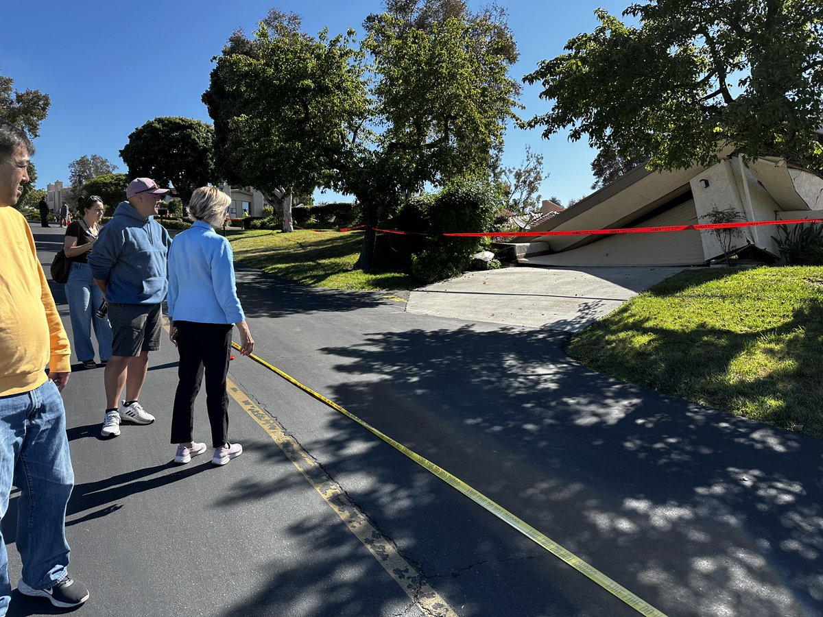
California homes in Rolling Hills Estates were evacuated on Saturday night after the ground shifted, leaving major cracks and some structures “visibly leaning,” officials said.
The homes in the Los Angeles County area were evacuated by firefighters when cracks began appearing in their support structures and the ground.
Walls and roofs began to fail as the land continued to slide, the county fire department showed in a video released on social media.
Los Angeles County Supervisor Janice Hahn, whose district includes the city, said she was notified Saturday night about the land movement and evacuation.
Residents of the affected homes “were told they had 20 minutes to get their belongings and get out,” Ms. Hahn said at a noon press conference Sunday at the site, where Rolling Hills Estates Mayor Britt Huff and officials from the county fire and public works departments joined her.
“To think that these homes were intact ... You know, yesterday afternoon and today, you can hear the creaking, the cracking, the crumbling,” Ms. Hahn told a news conference Sunday. “They’re going to fall.”
City and county officials said on Sunday that it is too early to speculate on what caused the ground to shift and that the matter is under investigation, with other homes in the neighborhood being monitored for movement.
“This neighborhood was built in 1978, and it’s been solid for 45 years,” Ms. Huff said. “So we’re very much shocked by what is happening here.”
Pete Goodrich, a building official with the city, said geologists will inspect the site and decide what can be done. He said there was substantial damage to the homes.
The land movement “could be due to the extensive rains that we’ve had ... but we don’t know,” Mr. Goodrich said of recent winter storms.
Southern California’s complex landscapes contribute to landslides, according to an overview by the U.S. Geological Survey in conjunction with the California Geological Survey.
The Palos Verdes Peninsula has long been prone to landslides, with the most dramatic one affecting Portuguese Bend—an area on the south side named after a whaling operation, now known for its natural beauty and native vegetation.
The Rolling Hills Estates are on the Palos Verdes Peninsula in southwestern Los Angeles County.
It’s unclear what caused the landslide, but city officials will look at several possible causes, including the winter deluge and a sinkhole that recently developed less than a mile away, though a building official said the latter explanation is “probably not” the reason.
The Portuguese Bend Landslide section of Rancho Palos Verdes (RPV) is the most active landslide area in North America, according to city officials, moving at a rate of as much as eight feet each year.
RPV is currently working to develop and implement a potentially $33 million plan to lessen the problem of continually shifting land, though the work faces multiple challenges, including from environmentalists concerned about the possible destruction of native habitats.
“There’s a serious risk of a major incident if we do not act fast enough,” RPV City Manager Ara Mihranian told the Daily Breeze in February. “(Palos Verdes Drive South) is sitting on wet soil. There’s a sewer line there. There could be a significant movement that may be very catastrophic, and that’s why this is very important.”
Rolling Hills Estates Councilmember Frank Zerunyan said on Twitter he had heard the ground cracking, and he saw a piece of a house’s wall crumble and fall into the canyon below and says the winter storms that hit Southern California late last year and early in 2023 may have contributed to the landslide.
“We have never seen this kind of damage to our infrastructure,” Zerunyan posted after the incident. “Mother Nature has not been kind to several homes. They are about to be at the bottom of the canyon very soon.”
Those homes continue to decline down the hillside, Los Angeles County Fire Capt. Sheila Kelliher said in an update on Monday morning.
“Things are still shifting there,” Ms. Kelliher said. “The hillside is still moving. We don’t know the extent of that movement, but geographical engineers are coming to the site to assess the situation further.”
In the coming days and weeks, city officials will likely look at other canyons in the town and determine how vulnerable they are, Mr. Zerunyan said. But he seemed pessimistic about whether anything could be done to shore them up.
“I would be reluctant about touching any canyons,” he said, “because I don’t want to make it any worse.”


