
The following four scenic drives around the San Francisco Bay Area make for excellent day trips.
Mount Diablo
Drive about 1 1/2 hours east of San Francisco for the scenic drive through Mount Diablo State Park to the top of Mount Diablo, in Contra Costa County. It is a curvy 11-mile drive if you enter through the North Gate Road Entrance on North Gate Road in Walnut Creek, and about a 15-mile drive if you enter through the South Gate Entrance on South Gate Road in Danville. There is a $10 entrance fee.
The drive will take you past woodlands populated with oak trees, such as the interior live oak and the California black oak, and in the springtime, past vistas of wildflowers, including fields of California poppies.
“[Mount Diablo State Park] has something kind of for everyone, whether you just want to drive to the top and enjoy the view, or if you want to go for a long hike, 15–20 miles, or if you’re coming just to learn about the history,” Cameron Morrison, state park peace officer, told The Epoch Times.
He said people visit year-round, but the biggest visitation period is from late winter to spring.
“People want to get outside after the winter, and then the wildflowers are a big draw as well,” he said. “The temperatures to hike and explore the park are much more accommodating during the winter and spring than they are in the summer.”

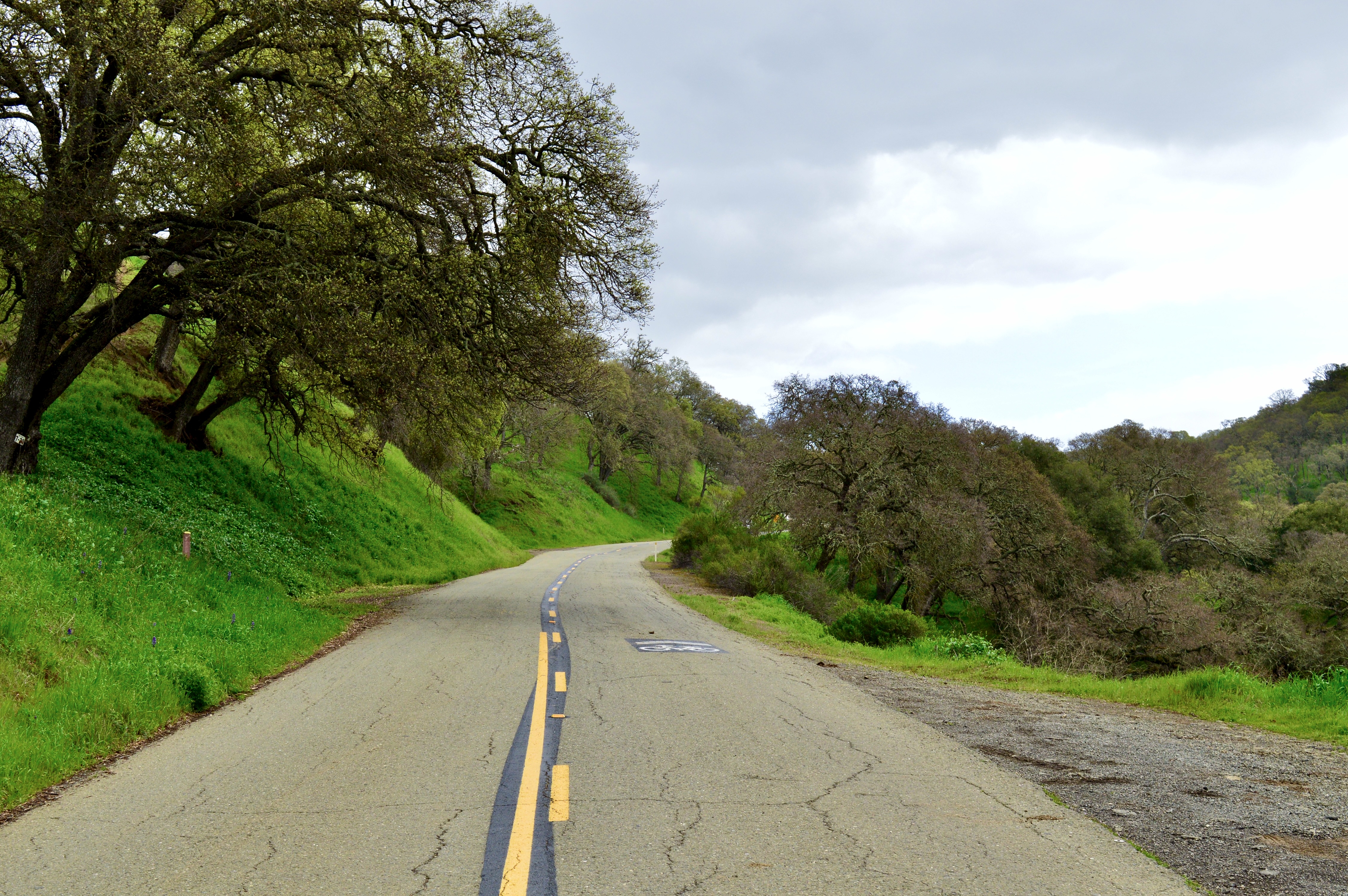
North Gate Road on March 15, 2025. (Keegan Billings/The Epoch Times)
Drivers share the road with bicyclists who may be heading to the top or zooming past on their way downhill.
Morrison said safety is paramount, and drivers must only pass bikes when it is safe and legal to do so.
Along the way, there are campgrounds, hiking trails, and stops with picnic tables for enjoying lunch. Also, multiple stops along the drive have bathroom facilities.

Livermore Valley Overlook in Mount Diablo State Park on March 15, 2025. (Keegan Billings/The Epoch Times)
Morrison said the park gets visitors not only from local areas, but also from out of state and overseas.
“Since there’s several airports nearby—Oakland, San Jose, San Francisco—we tend to get a lot of people that are either first day in the country or last day in the country, and they spend the night to camp, and then they will leave,“ he said. ”They drop off their rental car and then fly home or go somewhere else throughout the U.S. on their vacation.”
He said there can be some confusion when you look up directions to drive to the summit; you need to enter through the North Gate (1300 North Gate Road, Walnut Creek) or the South Gate (2675 Mt. Diablo Scenic Boulevard, Blackhawk) to drive to the top of Mount Diablo.
He noted that if you head to the Mitchell Canyon Staging Area (96 Mitchell Canyon Road, Clayton), you cannot drive to the top from that side. Some visitors have been disappointed after finding that out upon arrival.
At the end of the scenic drive, you arrive at the top of the highest peak, which has an elevation of 3,849 feet. There you will find the Summit Visitor Center and an observation deck with stunning views of the surrounding valleys of the Bay Area.

The view from the observation deck at the Mount Diablo Summit Visitor Center on March 15, 2025. (Keegan Billings/The Epoch Times)
On the walk up the circular stairway to the observation deck, visitors can see ancient marine fossils embedded in the sandstone walls of the summit building. The sandstone was quarried in the park.
With ideal conditions, you can see almost 200 miles away, according to Mount Diablo State Park’s website. The website states that summer days can be hazy, and you often get the best view on the day after a winter storm.

The view from the observation deck at the Mount Diablo Summit Visitor Center on March 15, 2025. (Keegan Billings/The Epoch Times)
According to the website, sights from the summit include the Golden Gate Bridge to the west; Mount Loma Prieta to the south in the Santa Cruz Mountains; Mount Saint Helena to the north; and to the east beyond the Central Valley, the crest of the Sierra Nevada. The view covers more than 8,539 square miles and parts of 40 of California’s 58 counties.
“It’s a pretty incredible park situated in the East Bay, and it’s an hour drive from pretty much all of the Bay Area and some parts of the Sacramento Valley,” Morrison said. “You get an amazing diversity of wildlife, plants. The view from the summit is really unparalleled. Then there’s also quite a bit of cultural history with Mount Diablo, and the Native American history as well.”

The view from the top of Mount Diablo on March 15, 2025. (Keegan Billings/The Epoch Times)
The North and South gates open at 8 a.m. and close at sunset. The visitor center is open from 10 a.m. to 4 p.m. There is a small gift shop and snacks to purchase at the visitor center, along with a room filled with informational exhibits for those who want to learn more about the natural history of the park.
Morrison said a good resource for people looking to visit is the Mount Diablo Interpretive Association.
“It’s an amazing group of volunteers that donate a ton of time and effort to make the park more enjoyable for all visitors,” he said.

Picnic tables at Juniper Campground, North Gate Road, Summit Visitor Center. (Keegan Billings/The Epoch Times)
In 1851, Mount Diablo was established as the initial point of the Mount Diablo Base Line and Meridian for land surveys covering two-thirds of California and all of Nevada. Tourists began taking wagons up in 1874, and viewing became more comfortable in 1942 when the Civilian Conservation Corps completed the visitor center.
Panoramic Highway
About four miles north of the Golden Gate Bridge off Highway 101 is the exit for California State Route 1 in Mill Valley, Marin County, which will lead you to Panoramic Highway. The scenic drive curves through Mount Tamalpais State Park.
The 13-mile drive takes you past valleys filled with redwood trees and Douglas firs as Panoramic Highway leads to Pantoll Road, continuing to Ridgecrest Boulevard to the East Peak of Mount Tamalpais.

Panoramic Highway on March 16, 2025. (Keegan Billings/The Epoch Times)
At the top of the East Peak, the elevation is 2,572 feet. A visitor center is open from noon to 4 p.m. on weekends. It has souvenirs for sale as well as informational displays connecting visitors with the natural and cultural resources found at the park. It costs $8 in cash to park.
There is also a short wheelchair-accessible loop, the Verna Dunshee Trail, which provides spectacular views of the surrounding Bay Area.

A sign for Mount Tamalpais State Park on March 16, 2025. (Keegan Billings/The Epoch Times)

The Richmond–San Rafael Bridge crosses the San Francisco Bay in front of Mount Tamalpais in Richmond, Calif., on April 28, 2021. (Justin Sullivan/Getty Images)
“We have many visitors who come to Mount Tam from all over the world just to take in the views and sometimes to get a break from the city,” Peter Ostroskie, visitor services manager, told The Epoch Times in an email. “East Peak is just one of the amazing places on Mount Tam. I would also suggest, before heading up, stopping at the Pantoll Ranger Station where you can get more information about the park.”
The Pantoll Ranger Station is located at 3801 Panoramic Highway, Mill Valley.

Panoramic Highway on March 16, 2025. (Keegan Billings/The Epoch Times)
He said on a clear day on the East Peak you can see all the way out to the Farallon Islands to the west and Mount Diablo to the east.
“It is an amazing place to have lunch and sit for a bit,” he said.
He said spring is a great time to visit and see the wildflowers.

Panoramic Highway on March 16, 2025. (Keegan Billings/The Epoch Times)
Besides Pantoll and Bootjack campgrounds in the park—where availability is on a first-come, first-served basis—at the beginning of the drive, right off Highway 101, is the Muir Wood’s Lodge in Mill Valley for visitors looking for a place to stay. There is also Good Earth Natural Foods, where you can grab food for a picnic.

Muir Wood's Lodge, Good Earth Natural Foods, Redwoods Haus Bed & Breakfast Inn, and Stinson Beach Market. (Keegan Billings/The Epoch Times)
On the way down from the East Peak, rather than heading back, the scenic drive continues another 12 miles on Panoramic Highway, connecting to California State Route 1 into Stinson Beach.
Visitors can find a place to stay in Stinson Beach at the Redwoods Haus Bed & Breakfast Inn and get food for a beach picnic at the Stinson Beach Market.

Stinson Beach on March 16, 2025. (Keegan Billings/The Epoch Times)
Sir Francis Drake Boulevard to Point Reyes Lighthouse
About 42 miles northwest of San Francisco is the town of Point Reyes Station in Marin County. The scenic drive starts there, heading out of Point Reyes Station on Sir Francis Drake Boulevard on a 20-mile drive to the Point Reyes Lighthouse.
The drive first heads through the small town of Inverness, providing views of Tomales Bay as the road travels alongside it.

Tomales Bay in Inverness, Calif., on March 16, 2025. (Keegan Billings/The Epoch Times)
There are multiple places to stay in Inverness, including Motel Inverness, Cottages at Point Reyes Seashore, and Tomales Bay Resort, which has kayak rentals. Also nearby are guided horseback trail rides with Five Brooks Ranch.

Motel Inverness, Tomales Bay Resort, The Inverness Store, and the Point Reyes shipwreck. (Keegan Billings/The Epoch Times)
Visitors can stop and buy food for a picnic at the Inverness Park Market (closed Sundays) or The Inverness Store. They can walk around back and check out the shipwrecked Point Reyes Boat before continuing on their journey.
The drive takes you past corridors of trees but then opens up to views of fields and rolling hills as you pass the Drakes Estero. It also passes a number of ranches, including the historic Straus Home Ranch, on the way to the Point Reyes Headlands.

Sir Francis Drake Boulevard on March 16, 2025. (Keegan Billings/The Epoch Times)

Drakes Estero. (Keegan Billings/The Epoch Times)

A cattle crossing on Sir Francis Drake Boulevard on March 16, 2025. (Keegan Billings/The Epoch Times)
As the drive curves along, you will also catch glimpses of the coastline. Visitors can detour a quarter of a mile to Point Reyes North Beach to take a walk in the sand.

Point Reyes North Beach. (Keegan Billings/The Epoch Times)
After arriving at the parking lot at the lighthouse, it is about a half-mile walk to the visitor center (27000 Sir Francis Drake Blvd., Inverness, CA 94937), which has information about the lighthouse, whale watching, and more.
“People from all over the world visit Point Reyes National Seashore,” Sierra Frisbie, park ranger at Point Reyes National Seashore, told The Epoch Times in an email.
She said any time of year is a good time to visit the Point Reyes Lighthouse. While summer brings warmer weather inland, the coastal area is often shrouded in a thick, cooling fog, which can provide a nice reprieve from summer temperatures.
She noted that winter can bring stretches of heavy rain and wind, but also some of the most beautiful, crystal clear days.
“January, March, and April are the best months to come to the lighthouse to spot gray whales during their annual migrations from Alaska to Mexico and back again,” she said. “Humpback whales can be seen feeding offshore in the summer and fall, and other species of whales can be seen year-round.”
The observation deck at the top of the stairs is open daily from 6 a.m. to 11:45 p.m., and the visitor center is open Thursday through Monday from 10 a.m. to 4 p.m. and closed Tuesday and Wednesday.

The path to the Point Reyes Lighthouse Visitor Center, a whale skull, the Ocean Exploration Center, and the lighthouse equipment building. (Keegan Billings/The Epoch Times)
From there, it is another 313 steps down to the actual lighthouse, which can be tough on the way back up.
A sign at the visitor center states that the Point Reyes Lighthouse holds the title of the windiest and foggiest place on the whole West Coast. It has an average of 200-plus foggy days per year and is the second foggiest place in North America after the Grand Banks in Newfoundland, a region that has only six more foggy days on average per year.
“Even in the summer, come prepared with clothing options to layer up appropriately,” Frisbie said. “The weather can change quickly.”

Point Reyes Lighthouse on March 16, 2025. (Keegan Billings/The Epoch Times)
If the wind hits 40 mph, the steps down to the lighthouse are closed for safety. In February 2025, there were 11 days on which the wind reached 92–100 mph.
Point Reyes Lighthouse was built in 1870 to warn mariners of headlands that posed a navigational hazard to ships traveling from San Francisco Bay to the north, the lighthouse’s website states. The lighthouse was in service for 105 years. When it was built, it used state-of-the-art technology of its time.
The Point Reyes Lighthouse boasts stunning views of the Pacific Ocean and the California coast. It is also an amazing piece of intact maritime history that saved many lives during its time in service, Frisbie said.
The lighthouse was retired from service in 1975, when the U.S. Coast Guard installed an automated light adjacent to and below the historic tower. The Coast Guard then transferred ownership of the lighthouse to the National Park Service, which has taken on the job of preservation.

An ocean view from Point Reyes Lighthouse on March 16, 2025. (Keegan Billings/The Epoch Times)
State Route 1 From Pacifica to Half Moon Bay
About eight miles south of San Francisco, this scenic drive starts in the town of Pacifica in San Mateo County.
Pacifica has many places to stay and eat, serving as a jump-off point for the drive.

Moonraker Restaurant, Rockaway Beach, Lighthouse Hotel, and a sign for Nick’s Seafood Restaurant. (Keegan Billings/The Epoch Times)

Pacifica State Beach in Pacifica, Calif., on March 22, 2025. (Keegan Billings/The Epoch Times)
The restaurant Moonraker in Pacifica is a great place to grab lunch before heading out on the drive, with its upstairs dining room overlooking the ocean and Rockaway Beach. Connected to the restaurant is the Lighthouse Hotel.
Next door are Nick’s Seafood Restaurant and the Sea Breeze Motel.
This drive hugs the California coast on Highway 1, also called the Pacific Coast Highway, giving stunning views as you drive past sea cliffs and beaches on the 15-mile drive.

The stretch of the Pacific Coast Highway between Pacifica and Half Moon Bay, Calif., on March 22, 2025. (Keegan Billings/The Epoch Times)

The stretch of the Pacific Coast Highway between Pacifica and Half Moon Bay, Calif., on March 22, 2025. (Keegan Billings/The Epoch Times)

The stretch of the Pacific Coast Highway between Pacifica and Half Moon Bay, Calif., on March 22, 2025. (Helen Billings/The Epoch Times)

The stretch of the Pacific Coast Highway between Pacifica and Half Moon Bay, Calif., on March 22, 2025. (Keegan Billings/The Epoch Times)
One of the many destinations of this scenic drive is right on the side of the highway: Sam’s Chowder House in Half Moon Bay, which has an outdoor dining patio overlooking the water. You can also dine at Barbara’s Fishtrap.

Sam’s Chowder House in Half Moon Bay, Calif., on March 22, 2025. (Keegan Billings/The Epoch Times)
Visitors can finish the drive by taking a stroll down Miramar Beach and watching the surfers, then checking out historic downtown Half Moon Bay.

Miramar Beach in Half Moon Bay, Calif., on March 22, 2025. (Keegan Billings/The Epoch Times)